


INSURANCE SATELLITE REMOTE SENSING
Price : 1-12 USD/km²
Combining satellite remote sensing technologies with rights confirmation data and land parcel segmentation technology can vectorize and spatialize the subject matter of insurance, then establish a spatial database of the subject matter of insurance to provide spatial data and analysis management support for insurance underwriting and claim settlement.
SATELLITE REMOTE SENSING FOR AERIAL IMAGERY ANALYSIS INSURANCE FEATURES
1
Accurate Risk Assessment: Satellite aerial imagery analysis insurance can provide detailed information on properties, such as their size, shape, location, and condition. This can help insurers to accurately assess the risks associated with a property and determine appropriate coverage and premiums.
2
Data breach coverage: Satellite aerial imagery analysis insurance often involves handling sensitive data, which can be vulnerable to cyber attacks. This aerial imagery insurance can provide coverage for data breaches and associated costs, such as legal fees, notification expenses, and credit monitoring services.
3
Data Analytics and Predictive Modelling: Satellites used for remote sensing in insurance can provide insurers with a wealth of data that can be used to develop predictive models and identify patterns and trends. This can help insurers to better understand risks and make more informed decisions about coverage, premiums, and underwriting.
4
Improved Underwriting: Satellite aerial imagery analysis insurance can help insurers to identify and evaluate risks that may not be visible through traditional methods, such as physical inspections or surveys. This can lead to more accurate underwriting and better risk selection.
5
Enhanced Customer Experience: By leveraging satellite aerial imagery analysis, insurers can provide their customers with more personalized and customized insurance solutions, based on the specific risks associated with their properties. This can lead to increased customer satisfaction and retention.
Chang Guang Satellite Technology Co., Ltd. is a satellite factory, we provide aerial imagery analysis insurance, aerial imagery insurance, satellite data service, etc. For more information, please feel free to contact us!
Contact : global jl1, 0431 81785188
Good deal: buying from seller
We invite you to read our terms of use. You can also visit our FAQ section and see our information section on the risks associated with counterfeiting.
|
This page is about importers and exporters of INSURANCE SATELLITE REMOTE SENSING Search in a category : B2B Services Search in a category : satellite, insurance, sensing, remote |
Report abuse

Tuesday, February 16, 2016
Quantity : 5000MT - Price : 450 USD / MT CIF
Inhibit tumor growth and improve disease resistance; Powerful anti-oxidant which extends life, and improves the memory; Neutralize the side effects of chemotherapy and radiation; Normalize blood pressure & balance blood sugar Lower cholesterol, lose weight. Support eye health...
KHUN JACK PARTNERSHIP LIMITED
- 50000 - CHIANG MAI
- +66 9 56 19 49 81
Report abuse
Thursday, August 01, 2013
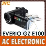
Quantity : moq:1pcs - Price : USD154.6
The black JVC GZ-E100 Full HD Everio Camcorder shoots Full HD 1920 x 1080 video. It features an SD/SDHC/SDXC memory card slot, back-illuminated 1/5.8" 2.5-megapixel CMOS image sensor and Konica Minolta HD lens. The high-quality HD lens supports 40x optical zoom, 70x Dynamic Zoom...
AC Electronic Ltd
- 999077 - HongKong
- +85 2 23 25 18 67
- +86 13501567844
Report abuse
Tuesday, July 07, 2026
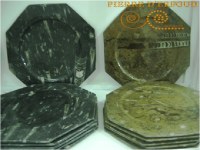
Our dishes, plates, cups are cut from a fossilized marble dating back to the Paleozoic era (450 million years). Our craftsmen have taken great care and ancestral know-how when extracted, its size and its polishing highlighting ammonites and Orthoceras that compose it. A mission all...
la pierre d'erfoud sarl
- pierrederfoud
- 52200 - erfoud
- +212661997865