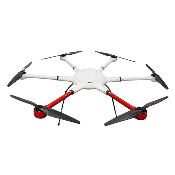


Aerial UAV—Control Survey
The Aerial UAV is to ensure the accuracy of aerial triangulation and determine the absolute position of objects in space. In the conventional low altitude digital aerial photogrammetry external specification, the layout of control points is specified in detail, which is the basis for ensuring the accuracy of large scale mapping. The technique of oblique photograph requires higher image overlap than traditional photography, and the requirement of image control point layout is not suitable for high resolution unmanned aerial UAV oblique photogrammetry. Aerial UAV usually adopts GPS positioning mode, and has POS data itself. It plays a significant role in determining the relative position between images, and can improve the accuracy of empty three computation.
1 Conventional three-dimensional modeling
Based on the Smart 3D algorithm, a control interval can be provided from the angle of the final aerial triangulation feature point-cloud. The proposed value is to set a control point at every 20000~40000 pixels, in which the difference POS data (relatively accurate initial value) can be relaxed to 40000 pixels, and at least 20000 pixels of the differential POS data are set. At the same time, it should be applied flexibly according to the actual terrain and terrain conditions of each task, such as very large terrain undulating, large area vegetation and surface water features very few, and need to increase the control point. The measurement of control points adopts attached traverse measurement to get high-precision location information.
2 Safeguard of emergency surveying and mapping
After the earthquake, landslides, debris flow and other natural disasters, in order to obtain the disaster area's three-dimensional data, we can not control the measurement according to the traditional operation mode. By reading the coordinates of the Google map, the handed GPS measurement, and the RTK measurement, the few control points of the disaster area can be quickly obtained, and the real three-dimensional model of the disaster area can be generated to provide assistance for post-disaster relief.
3 The selection requirements of point location
The target image of the image control point should be clear, and select the place where the spot is easy to be identified, is fixed and easy to measure.When the condition is available, we can make the mark point of the control point of the field work first, usually choose the white (or red) paint to mark the cross sign, and test several images before the aerial photography to ensure that the cross sign can be correctly identified on the oblique image. After the control point measurement is completed, it is necessary to make the control point distribution map in time, control the spot information table, accurately describe the location and position information of each control point, and facilitate the use of the internal pricking points.
Hot Products
Industry drone T2


Contact : flying titan, +75 5 21 53 90 34
Good deal: buying from seller
We invite you to read our terms of use. You can also visit our FAQ section and see our information section on the risks associated with counterfeiting.
|
This page is about importers and exporters of Aerial UAV—Control Survey Search in a category : Electronics / Computers Search in a category : aerial, survey, uav—control |
Report abuse
Friday, September 27, 2013
Quantity : 7 - Price : 1,00 €
As owner, we have for sale the following 6x RYOBI's machines : Ryobi 512, Year 1997 – Ref C9889 36.5x52, 2 colors- S/N 1582 , ca. 7 Mio impression - Standard Dampening - Stream Feeder - Sidelay & Double Sheet Detector - Quick Release Clamps - Chromed Impression Cylinder - Plate...
ACS DIFFUSION s.a.s.
- acsdiffusionsa
- 42952 - Saint-Etienne
- 0033 (0)4 77 92 77 88
- 06 10 63 37 83
Report abuse

Monday, March 04, 2013
Quantity : 30 - Price : $395.00
It's not just phone we're talking about... it's smart phone... it's Samsung GALAXY S III. It has the looks and a symmetry which would make you proud to hold it in your hands. You couldn't ask for more imposing façade than its 4.8 inches HD Super AMOLED high-definition display. It delivers...
Report abuse
Wednesday, August 06, 2014
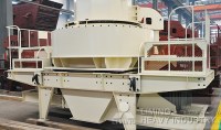
Vertical Shaft Impact crusher (VSI Sand Making Machine) uses a unique rock on rock crushing method employing a high speed rotor with crushing chamber of the equipment. Velocity is applied in Vertical Shaft Impact crushers as the resulting force, to break stone particles. While applying...
Henan Liming Heavy Industry Science & Technology Co.
- 75001 - paris
- 08 63 72 12 34